


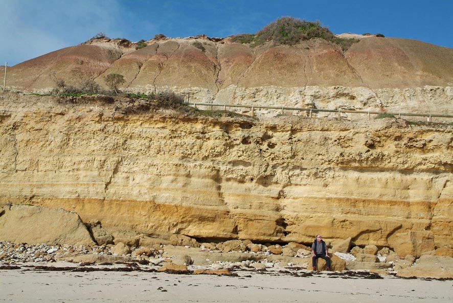
 THE AUTHOR ON THE BEACH AT PORT WILLUNGA, BELOW THE FAMOUS STAR OF GREECE RESTAURANT. THE TOP LAYER IS THE VERY RECENT (PLEISTOCENE) NGALTINGA CLAY, A STICKY WATER-RETAINING FORMATION WHICH IS NOT IDEAL FOR VITICULTURE. NEXT LEVEL IS THE PALE BURNHAM LIMESTONE (2.6 MILLION YEARS), THEN THE CALCERIOUS FOSSILIFEROUS HALLET COVE SANDSTONE (JUST A LITTLE OLDER), AND THE YELLOW-BROWN PORT WILLUNGA FORMATION (23 MILLION YEARS) DIPPING GENTLY SOUTHWARD AT THE FOOT OF THE CLIFF. photo EMILY SHEPHERD ... to view the new map in medium res CLICK HERE
Orogenies, Effluvia and Exposures ... Uplifts, Disruptions and Faultlines ... Chaotic And Random Complexities
by PHILIP WHITE
The Universe is about 13.75 billion years old; the Earth about 4.54 billion.The best simple analogy – the key – to understanding the geology of our planet is to consider it as a pot of stew.
The simmering, molten liquor below is the Earth’s core and mantle, which together are about 6,300 kilometres deep, meaning it’s about that distance to the centre. The globs that form on the much cooler top of the stew gradually enlarge, shrink, dissolve, sink, oxidize, and constantly move about.
We live on this unstable floating crust, which varies from 5 to 75 kilometres thick.
The liquor in the stew of Earth is mainly molten nickel and iron. At the centre, the pressure is so intense that the metals cannot liquefy: there’s a solid metal ball there 2,600 kilometers in diameter. Surrounding that is the liquid part – the Outer Core and Mantle. This varies in fluidity, from quite liquid near the core, to plasticine closer to the crust.The core of the Earth rotates at a faster speed than its crust.
The oldest big rocks on Earth are suspected to the Nuvvuagittuq greenstones on the tundra on Hudson Bay, Canada. These are currently claimed to be 4.28 billion years of age. The oldest tiny rocks found on Earth are the particulate Western Australian zircons, at 4.36 billion years.
To put these vast ages in perspective, the alluvial sand of Uluru – Ayer’s Rock – was being deposited only about 550 million years ago. About 400 million years ago, it was being tilted ninety degrees to the vertical. During the last 300 million years it has been exposed and shaped to its current form.
 ULURU - AYERS ROCK - THE GEOLOGICAL, FIGURATIVE, MYTHICAL AND SPIRITUAL NAVEL OF AUSTRALIA WAS BEING LAID DOWN AS SANDSTONE SEDIMENT ABOUT 550 MILLION YEARS AGO. BY THAT POINT IN HISTORY, ALL THE OLD ROCKS SURROUDING AND UNDERLYING McLAREN VALE HAD ALREADY BEEN FORMED. photo NT tOURISM
Australia
The key to understanding Australia is to consider relatively recent times, and commence our natural history about three-quarters of the way along.
Between 570 and 510 million years ago, two globs - East and West Gondwana - joined together, covering one side of the Earth from the Equator to the South Pole.
Almost a mirror-image, a similar sized glob, Laurasia, stretched from the Equator to the North Pole.
180 to 200 million years ago, Gondwana and Laurasia broke apart, and each drifted closer to its Pole.
About 150 million years ago, Gondwana began to break up. It has since broken into Antarctica, South America, Africa, Madagascar, Australia-New Guinea, New Zealand, Arabia, and the Indian subcontinent.
About 80 million years ago, Australia was separating from Antarctica, moving back towards India at about the speed at which your fingernails grow.
 McLAREN VALE: THE WILLUNGA EMBAYMENT, LOOKING SOUTH. THE PROMINENT RIDGE IN THE BACKGROUND IS THE WILLUNGA ESCARPMENT, FOLLOWING THE LINE OF THE WILLUNGA FAULT. IN THE FOREGROUND IS THE GORGE OF THE ONKAPARINGA, VAGUELY FOLLOWING THE OCHRE COVE-CLARENDON FAULT. THE ROCKS THIS SIDE OF THE ONKAPARINGA ARE FROM THE UMBERATANA GROUP, OLDER THAN 650 MILLION YEARS, AND THE OLD ROCKS ON THE OTHER SIDE OF THE WILLUNGA FAULT STRETCH FROM 520 MILLION YEARS TO 1.6 BILLION. BETWEEN THE TWO, IN THE WILLUNGA EMBAYMENT SLUMP, ARE THE MARINE AND RIVERINE SEDIMENTS OF McLAREN VALE, ALL LAID DOWN DURING THE LAST 56 MILLION YEARS, . photo STACEY POTHOVEN
The Geology of McLaren Vale
McLaren Vale lies in the Willunga Embayment, a wedge-shaped depression between two ancient faultlines in rocks older than 500 million years.
After a great period of inactivity, about 56 million years ago, in the Eocene Epoch, these fault lines reactivated, and the old Neoproterozoic rocks between them subsided, forming an embayment into which younger sediments began to wash down from the mountains to the east, and in from the ocean to the west and south.
These two localized faults are the Ochre Cove-Clarendon Faultline to the north, and the Willunga Faultline to the east.
The western side of the triangle is bordered by the sea: the Gulf St. Vincent.
 BOTTOM THIRD OF THE MAP. THE BLACK DOTTED LINE TRANSVERSING THE IMAGE IS THE WILLUNGA FAULTLINE, WHICH MARKS THE WILLUNGA ESCARPMENT. THE ROCKS TO THE SOUTH-EAST OF THIS, IN THE MOUNT LOFTY RANGES, ARE ALL OLDER THAN 520 MILLION YEARS, AND STRETCH BACK TO 1.6 BILLION. THE YOUNGER SEDIMENTARY LAYERS TO THE NORTH WEST, IN THE WILLUNGA EMBAYMENT, ARE ALL YOUNGER THAN 56 MILLION YEARS. ALL VINEYARDS, ROADS, WINERIES AND VILLAGES ARE SHOWN. THE KEY TO THE YOUNGER ROCKS IS IN THE TOP LEFT HAND CORNER OF THE SHEET.
The principal riverine sands to descend from the ancient Mount Lofty Ranges to the east are called the Maslin Sands. These underlie all of the Willunga Embayment. At their deepest, before they disappear beneath the Gulf at Maslin Beach, they have been intersected by water bores more than 300 metres below the surface. They are covered with more recent marine sediments, so they are not oxidized, and at depth remain loose and sandy enough to scoop up for building materials. Where they tilt to the surface, in the north-east corner of the Embayment, they are oxidized, and, in places, have turned to sandstone. As water rich in iron has invaded their interface with the younger sediments and sands above them, ironstone has formed.
About 40 million years ago, the sea moved in to fill the Gulf St Vincent, which stretched as far as Leigh Creek, on the western flank of the Flinders Ranges. On its shallows thickly-vegetated swamps developed. In some places, these have become brown coal.
 LOOKING SOUTH-EAST ACROSS McLAREN VALE TOWARD THE WILLUNGA ESCARPMENT, FORMED WHEN THE LAND THIS SIDE OF THE FAULTLINE THERE SLUMPED, TO BE REFILLED WITH SANDS FROM THE RANGES WHICH ONCE TOWERED BEYOND, AND VARIOUS LAYERED SEDIMENTS FROM THE OCEAN, OUT OF FRAME TO THE RIGHT photo MILTON WORDLEY.
For 25 million years this Tertiary ocean covered the Nullarbor, the Mallee and the South East of South Australia. Hundreds of metres of mud, fossils, and lime were deposited.
15 million years back, the sea retreated, only to invade again five million years ago, this time depositing sand and marine clay on the Adelaide Plains, the Mallee and the Limestone Coast. These sands and clays formed the aquifers of Adelaide, Willunga and Noarlunga, which now contain mainly fresh water.
 There are two aquifers in the Willunga Embayment. These fill with fresh water which flows in creeks down from the ranges and the escarpment. When these creeks reach the Willunga Fault, much of their water disappears underground into that buried fissure, to refill the aquifers, pushing the brackish water back out beneath the Gulf.
About 2.5 million years ago the most recent major ice age commenced. The polar ice caps grew very large, taking up much of the planet’s water. 60,000 years ago, when the icecaps were enormous, the waterline was 120 kilometres distant. One could walk to Kangaroo Island. The gulf was a vast marshy plain with the River Vincent flowing down its centre, bringing south more sands, gravels and clays. Giant marsupials grazed here.
As the ice caps expanded and contracted, the sea repeatedly came and went, laying down various clearly delineated sequences of marine sediment. When it retreated, cold, windy, desert conditions prevailed, during which windblown silts were laid down, and lines of sand dunes were left. The reefs below the water off Port Noarlunga are remnant dunes from these times.
Other sediments washed down from the Mount Lofty Ranges to the east, across the Willunga Faultline into the Embayment, and on into the Gulf St. Vincent.
Over the millennia, various uplifts, disruptions and erosional effects have exposed these riverine and marine sedimentary sequences in an apparently chaotic and random manner, making the surface geology very complex, varying from one site to another.
 GEOLOGIST JEFF OLLIVER AND THE AUTHOR EXAMINING THE UNCONFORMITY IN THE CUTTING NEAR CHAPEL HILL. THE RED NORTH MASLIN SANDS (50-56 MILLION YEARS) SIT DIRECTLY ATOP THE PALE BURRA GROUP (OLDER THAN 750 MILLION YEARS). THERE ARE 700 MILLION YEARS MISSING. photo KATE ELMES
The Geology Of Yangarra Estate
Yangarra’s geology is sedimentary.
Yangarra lies against the foot of the Willunga Escarpment on the Willunga Faultline near the eastern extreme of the Willunga Embayment, further from the Gulf than any other major McLaren Vale vineyard.
Yangarra’s sediments were deposited by streams flowing east-west from the Ranges down to the Gulf, and not by the west-east intrusions of the ocean which filled much of the Embayment. They are riverine, not marine.
 THE AUTHOR AT AN OLD IRONSTONE PIT AT YANGARRA. HE IS INDICATING THE 600 MILLION YEARS PLUS BEDROCK BELOW THE GRAVELLY, QUARTZY, 50 MILLION YEARS PLUS NORTH MASLIN SAND BY HIS KNUCKLES - AN UNCONFORMITY. THIS IS THE ONLY KNOWN EXPOSED EXAMPLE OF THIS OVERLAY AND THE 500 MILLION OR SO YEARS OF GEOLOGY WHICH IS QUITE SIMPLY MISSING. IT'S NOT THERE photo- KATE ELMES
The major geological formation below Yangarra is a thick layer of North Maslin Sand. This was washed down during the Eocene Epoch (34-56 million years ago), across the fault, from the very ancient sandstones (up to 1.6 billion years old) of the Mount Lofty Ranges. Twenty-five kilometers to the west, on the coast near Maslins Beach, this same yellow, orange, red and brown sand is mined for use as construction and decorative sand.
In those 150 metre deep pits, where the sands are not oxidized, they are still loose and easily dug by machines.
But where the North Maslin Sand tilts upward to the surface at Yangarra, it's exposed to oxygen and weather, which has turned it to stone. The penetration of iron-rich water over the millennia has converted much of this cap to ironstone. There are ironstone ridges running north-south through the vineyard, growing fruit of great intensity and strength.
The North Maslin Sand reaches its north-easterly extreme beyond Baker Gully about five kilometres north east of Yangarra. Here, this thinning iron-cemented sandstone lies directly atop the very old meta-sediment of the Neoproterozoic Burra Group, which is older than 750 million years. In the roadcut on Chapel Hill Road, one can place a finger on the unconformity where 700 million years of geology is simply missing. The older Neoproterozoic rocks were deposited before Gondwana had formed and moved itself to the South Pole, away back when multi-cellular life was only just beginning.
 1946 VINTAGE GRENACHE BUSH VINES IN THE SEMAPHORE SANDS OF THE HIGH SANDS VINEYARD IN THE RECORD HEAT BLITZ OF 2009. THE NEW YANGARRA ORGANIC VITICULTURAL REGIME NOW ENSURES THAT NO SAND REMAINS BARE OF GRASSES AND HERBS, WHICH WILL DRAMATICALLY REDUCE REFLECTED HEAT DAMAGE WHENEVER ANOTHER HEATWAVE OF SUCH VICIOUSNESS OCCURS photo PHILIP WHITE
At Yangarra’s western extreme, where the North Maslin Sand begins to plunge gently to the coast, an overlying clay layer has formed. This is covered by a dune of aeolian, or wind-blown Semaphore sand, blown here in the last 10,000 years. Although it was not deposited by the sea, the Yangarra crew humorously call it The Beach.
In contrast, at the eastern side of the vineyard, along the faultline below the range, the thinning North Maslin Sand is covered in bits of quartzite and rounded riverine siltstones and sandstones in loose sand and clay, depending on when it was washed down, and from where.
This alluvial fruitcake, collectively called the Kurrajong Formation, was broken by water and ice from the 750+ million years old Burra Group formations which once towered mightily in the mountains to the east of the faultline.
It was dumped during the Pleistocene (10,000 – 2.6 million years ago), when glacial action, and vast meltings, were repeating widespread.
Interestingly, these rounded riverine stones and glacial pebbles are thick in the free-draining sandy soil beneath the Yangarra Roussanne vineyard. These rocks are similar to the galets – the rounded riverine and glacial stones – transported from the Alps and deposited about two million years ago in the Northern Rhone around Hermitage. These galets are highly regarded by Rhone Roussanne makers.
 PETER'S CREEK IS A MERE TRICKLE AS IT FLOWS THROUGH THE YANGARRA FARMHOUSE FRONT GARDEN. FIFTY MILLION YEARS BACK, IT'S GIANT FOREBEAR WAS A CONDUIT FOR MASSIVE EFFLUVIA, USING ENORMOUS ENERGY TO WASH NORTH MASLIN SANDS AND GLACIAL DROPSTONES FROM THE CARBONIFEROUS-PERMIAN ONTO THE BASE OF THE WILLUNGA EMBAYMENT photo PHILIP WHITE
Peter’s Creek flows through the front garden of the old Yangarra farmhouse. Upstream, across the fault at the crest of the escarpment, lies a discrete formation of geology from the middle of that 700 million year gap visible in the cut on the ironstone knoll. This is a basin from the Carboniferous-Permian period, about 300 million years ago. All the other geology from that gap is still missing. This incidence is freaky.
To add complexity, this formation is peppered with dropstones. These are stones from great distances away, which have been picked up by glacial ice, to be deposited as dropstones when and where the ice melts.
It will involve more forensic geological work, but this rare incidence of the Carboniferous-Permian may explain the peaty aroma of some of the local wines which grow along the ridges and north in Baker Gully where the North Maslin Sands are close enough to the surface to be near the vine roots. The Carboniferous-Permian is the epoch of mighty coal and peat swamps; in this formation most of the world’s oil shale and oil reside.
The aroma could also come from the lesser bituminous formations laid down 40 million years ago. To the north of Yangarra in Baker Gully there’s a quarry which shows an exposed bituminous layer; above and nearby is a field from which vineyard ripping has drawn up chunks of fossilized timber. These fossils appear to be coniferous in type: they resemble native pine, or even Huon Pine.
Although vine roots cannot absorb oil, the aroma of this bituminous layer would readily penetrate the clay and sand above, to influence the flavour of the water tapped by the vine roots.
It is this amazing complexity, with fragments of stones from so many eras and locations mixed with those that have actually formed on site, that makes Yangarra Estate’s suite of vineyards so unique.
Now the ground work has been done, further geological forensics will help uncover more detail, and more keys to the secrets of the beautiful flavours that this complex, fascinating geology delivers.
 PETRIFIED CONIFER TIMBER FROM BAKER GULLY. THE SHINY SPECKS ARE QUARTZ. THIS COULD WELL HAVE BEEN WASHED DOWN PETER'S CREEK IN A MAJOR EFFLUVIUM.photo PHILIP WHITE


1 comment:
a really great story and well written thank you
from a local geology fan
great pictures too
Post a Comment